
Sokor 1 Fm
Type Locality and Naming
Subsurface: Wells in the Termit and Ténéré Sub-Basins
References: Nasaruddin et al., 2017; Zhou et al., 2017; Hamma Ada & Harouna, 2019; Ahmed et al., 2020; Lai et al., 2020; Amadou et al., 2021.
Equivalent(s): This sub-surface formation correlates with the surface formations of the upper part of the Termit Fm, the upper part of the Galhama Fm, the upper part of the Bilma Fm, the upper part of the Emi-Bao and the upper part of the Totomaye Fm.
Lithology and Thickness
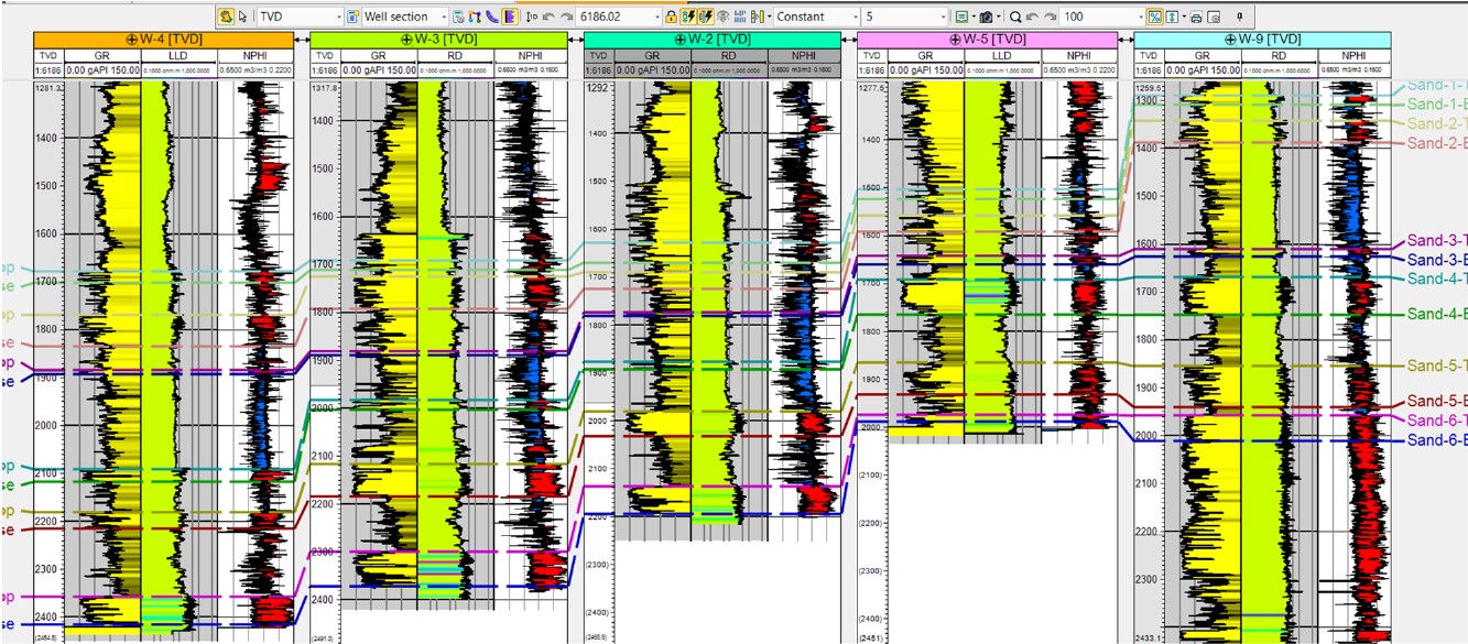
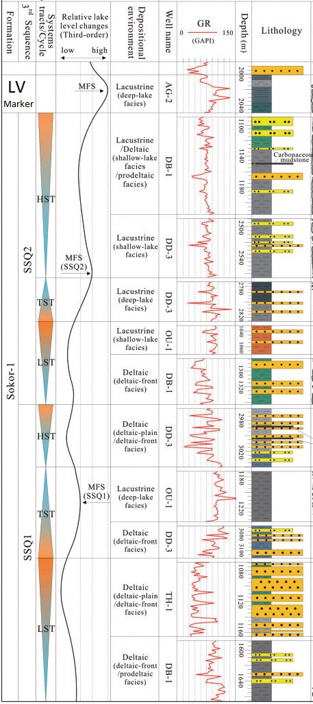
Major oil-producing reservoirs composed of fluvial/alluvial, deltaic alternating sandstones interbedded with lacustrine mudstone/shale deposits. The sandstones are divided into six (6) sand groups: E0, E1, E2, E3, E4 and E5 (Fig. 1) and are composed of quartz, lithic quartz-arenite and rarely lithic feldspathic-quartz-arenite. The reservoirs of the best quality were deposited in braided river channel environments. Mudstone and shale intercalations within the Sokor 1 Fm are very effective as top and lateral seals. The Sokor 1 Fm is divided into two-third order sequences and six systems tracts. Six types of source rocks can be distinguished within the three depositional environments of the sequence stratigraphic framework (Fig. 2): (1) deep lake mudstones/shale deposited in the deep-water lacustrine facies, (2) shallow lake mudstones and carbonaceous mudstones occurring in the shallow lake environment, and (3) deltaic-front mudstones and prodeltaic mudstones developed in the deltaic facies. Thickness: 300 m in the Termit Sub-Basin and 300 to 900 m in the Ténéré Sub-Basin. The thickness of sandstone in the Sokor 1 Fm varies from less than 1 m to 50 m (2% of the sandstone is above 40 m), representing composite bodies of stacked channels.
[Figure 1. Correlation panel across wells for the reservoir intervals of the Sokor 1 Fm (Source: Amadou et al., 2021).]
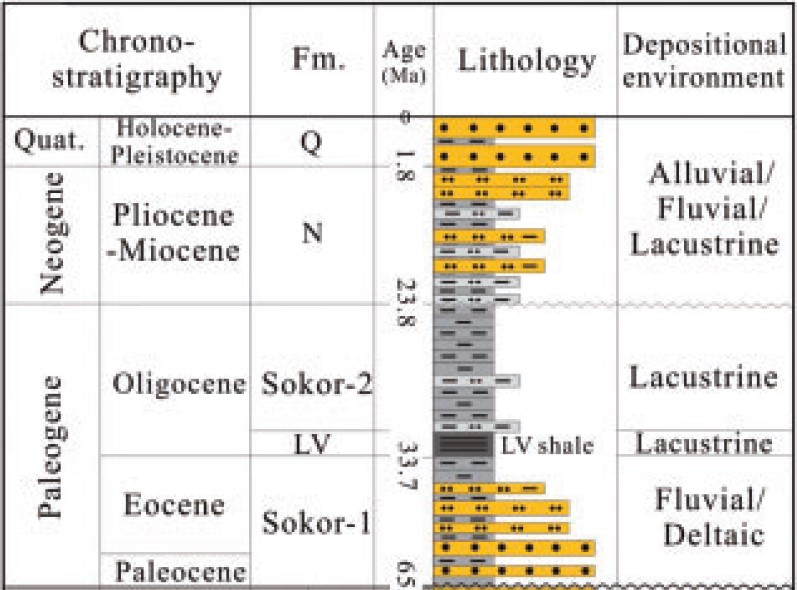
[Figure 2. Stratigraphic column of the Termit Basin showing the Sokor 1 and Sokor 2 formations and the LV shale marker at the base of Sokor 2 Fm (Source: Lai et al., 2020)]
[Figure 3. The stratigraphic sequence column in the Termit Sub-Basin showing the evolution process of the relative lake level and depositional facies of the Paleogene Sokor 1 Fm and LV shale marker in the Sokor 2 Mbr (Source: Modified from Lai et al., 2020).]
Relationships and Distribution
Lower contact
Underlain by the Madama Fm
Upper contact
Overlain by the Sokor 2 Fm. The "LV shale marker" layer at the base of the Sokor 2 Fm, consisting mainly of pure lacustrine deep-water shale/mudstones, is generally accepted as the regional marker for identifying the top surface of the Sokor 1 Fm.
Regional extent
Wells in the Termit and Ténéré (Graben) Sub-Basins.
GeoJSON
Fossils
None detected
Age
Depositional setting
Continental (fluvial/alluvial, deltaic, lacustrine). These series of lacustrine deep-water shale/mudstones that developed in the semi-deep to deep lake environment indicate that a gradual lake expansion occurred in the Termit Sub-Basin from the Sokor 1 Fm to the LV shale marker. However, the lake level change cycle controlled the deposition process of sediments within a third-order sequence period.
Additional Information